- Thumbnail
- Resource ID
- a928380e-6f6a-11e9-8d7d-000d3ab6a624
- Title
- TM-BELIZE-Coastal Planning Regions-100.000-2010
- Date
- May 5, 2019, 2:19 p.m., Publication
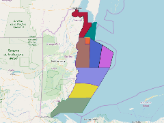
- Abstract
- Coastal Planning Regions 3km zone of influence: Produced in 2010 by CZMAI with a preferential scale of 1:100,000. With a national coverage in polygon format.
- Edition
- --
- Owner
- gridanode
- Point of Contact
- devrsgis@gmail.com
- Purpose
- --
- Maintenance Frequency
- None
- Type
- not filled
- Restrictions
- None
- None
- License
- None
- Language
- eng
- Temporal Extent
- Start
- --
- End
- --
- Supplemental Information
- No information provided
- Data Quality
- --
- Extent
-
- long min: -88.9637052374
- long max: -87.3767606700
- lat min: 15.8908880087
- lat max: 18.4901634897
- Spatial Reference System Identifier
- EPSG:900913
- Keywords
- no keywords
- Category
- None